| |
 |
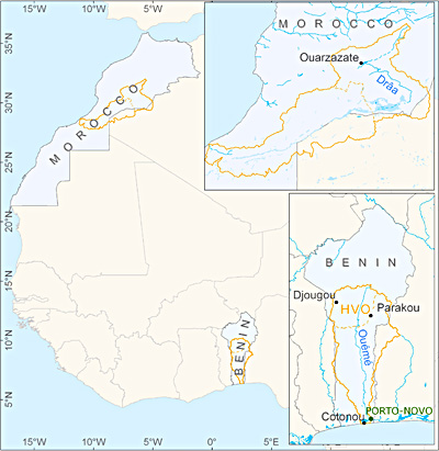 - Fig.: The catchments of the Drâa in Morocco and the Ouémé in Benin. The Upper Ouémé Valley (French: Haute Vallée de l'Ouémé = HVO) is a focus of research activities.
Choice of Catchments
West Africa was chosen because it has experienced the most pronounced inter-decadal variability of climate in the world during the 20th century. Relations to the climates of Europe might exist via complex atmosphere-ocean interactions in the area of the tropical/ subtropical and north Atlantic ocean.
Along a transect between the Atlas Mountains and the Gulf of Guinea two reasonably sized river catchments were chosen according to the following criteria: feasibility (< 100.000 km²), availability of pre-existing data sets, politically stable conditions, relevance, and representative-ness in the following sense: the Drâa catchment in the south east of Morocco is typical of a gradient from humid/sub-humid subtropical mountains to their arid foothills; the Ouémé basin in Benin is typical of an alternating sub-humid climate ("Guineo-Soudanien") of the outer tropics embedded within a transect from the Sahelian to the Guinean Coast climate.
Situation
Shortage of fresh water is expected to be the dominant water problem of the 21st Century and one that, along with water quality, may well jeopardise all other efforts to secure sustainable development, and even in some cases lead to social and political instability. Fresh water has already become critically scarce in many regions. Some estimates suggest that today the amount of fresh water available for each person in Africa is only about a quarter of that in 1950. Fresh water supply could become problematic especially in parts of Northwest and West Africa, where about 30 years of drought have been observed. The physical mechanisms responsible for the variability of climates in these regions are still relatively poorly known and understood. The possibility of human-induced climate change adds additional serious aspects to the challenging water-related problems already encountered in many parts of the world.
Apart from the decreasing availability of fresh water per capita both in Morocco and in Benin the current situation north and south of the Sahara is also characterized by increasing population (population growth rate more than 3% per year), increasing degradation of the natural vegetation due to overgrazing (Morocco), demands in fire wood, and shifting cultivation (Benin). As a consequence soils quickly erode in Morocco (to a lesser degree also in Benin) and salt contents rise due to the irrigation practices. In combination the aforementioned factors are likely to accelerate the degradation and desertification processes for the coming decades.
Situation in the Wadi Drâa Catchment
Moroccan precipitation is strongly related to the large-scale atmospheric circulation over the subtropical and extratropical North Atlantic and the Mediterranean Sea, with the bulk of precipitation occurring in winter between November and March). Since the late 1970s, Morocco has experienced a number of extremely dry winter seasons, the causes of which are not fully understood. Against this background, the development of sustainable water resource management is even more a necessity. The considered wadi Drâa possesses two main tributaries, the wadi Dades and the wadi Ouarzazate which drain the south-eastern and the south-western parts of the Atlas and confluence near the city of Ouarzazate thereby forming the wadi Drâa. At the site of confluence the construction of a storage lake was completed in 1972 with an original storage capacity of 560 million m³.
Due to strong sedimentation a capacity of only 440 million m³ remains today. Approximately 250 million m³ of stored water is released in normal years for irrigation purposes. The irrigated perimeter covers a total area of approximately 26.500 ha. Since the snow melt in spring contributes significantly to the annual discharge of the main storage lake tributaries, diagnosing the spatial distribution of accumulated snow water equivalent in the elevated areas of the catchment is particularly desirable. An effective and sustainable management of water in the Drâa valley is essential to enable the competing users (water power generation, irrigation, domestic consumption) to have adequate supplies, and to prevent social tensions related to water resources.
Situation im Einzugsgebiet des Ouémé
Since the early 1970s tropical West Africa has suffered from a prolonged drought that reached its first climax in the first half of the eighties. The average rainfall deficit over 1971-1990 was of the order of 180 mm/year compared with the interval 1951-1970. All climatic zones, from the semi-arid Sahel and the subhumid Sudanese zone down to the humid Gulf of Guinea, have been affected. As a consequence river discharges in West Africa have decreased by about 40-60% in recent decades, causing shortages in river water available for domestic and agricultural purposes. As a consequence this has led to extensive migrations in the past.
The prolonged West African drought has already brought about a profound deterioration in the economic and social development of the West African countries, among which is Benin. At a number of "hot spots" in the study area, land use and land cover changes were already detected for the last 20 years by remote sensing. Migration into the study area takes place in an institutional vacuum and without governmental support. The consequences are transformations of socio-economic structures on the local scale, changes in land use patterns and effects on quantity and quality of drinking water, leading to local hazards for livelihood due to water scarcity and waterborne diseases.
|
|